Maps of Allatoona Pass
Map Legend
The Battle
Opening Moves
10:00 AM
10:20 AM
10:30 AM
10:40 AM
10:50 AM
11:00 AM
12:00 PM
1:30 PM
2:00 PM
Then and Now
Order of Battle
Wargaming Allatoona Pass
Bibliography |
Maps of Allatoona Pass
| This map was created from U.S. Geological Survey maps, as well as primary and secondary sources. It shows the battlefield as it appeared at the time of the battle. |
|
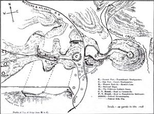
This map is a sketch of Allatoona Pass made by Major General Sameul G. French. Taken from Two Wars: An Autobiograhy of Gen. Samuel G. French... .
. |
|
| This is a map showing the modern changes made to the battlefield since 1864. |
|
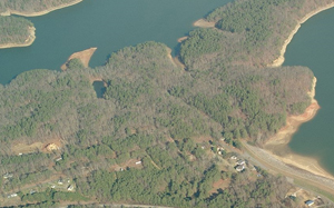
This is a modern aerial view of the Allatoona Pass battlefield.
Image courtesy of Google Earth™ |
|
This is a modern "bird's eye" view taken at a 40° angle.
Courtesy of Microsoft® Visual Earth™ |
|
|
|